|
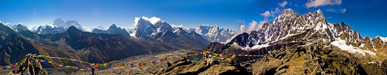
| panorama from Gokyo Ri |

From the equatorial jungles of Gabon we were teleported to the highest mountains in the world - Nepal. The change was not only climatic but also cultural, linguistic, and culinary. Vishnu and his girlfriend Sofi from Couchsurfing met us at the airport in Kathmandu and helped us to orientate in this new environment. We fell in love in Nepal at first sight. After Africa Kathmandu seemed like a city of abundance. You can buy whatever you want and it can be very cheap (with enough bargaining). Equipment stores were stocked with everything for trekking and climbing and food was delicious and various. We tried from everything a lot and we could not get enough of the Nepali specialties. We gave the lens and the computer for repair and for a day or two they were ready! We stayed two days with Vishnu who had trekked a lot in the mountains and explained us the possible routes. We, of course, wanted first to see Everest and its neighboring highest peaks on Earth. Everest, Sagarmatha in Nepali or Chomolungma in Sherpa language, was very far away. We didn't want to fly to Lukla, as did more than 90% of the tourists visiting the national park "Sagarmatha".We preferred to travel 12 hours by bus and six days by walk to Lukla, as did the first expeditions to Everest. In fact the first expeditions started walking straight from Kathmandu. Because of the mountainous terrain, there are not many roads in northern Nepal, and the few roads were more extreme than the trekking itself. Just imagine how a bus travels 120 km in 12 hours almost without stopping. We decided that the adventure is crazy enough and there’s no need to hitch-hike. We started preparing for the trek enthusiastically - permits, tickets, equipment and essentials. Guide and porter were not required, but the fees for national park were about 30 Euros per person. It would be longest trek in our lives - nearly 30 days walking in the mountains, more than 340 km. We had to be prepared for anything. We moved to another couchsurfer - Manjil, who was also hitchhiker and even wrote in a local magazine about hitch-hiking. He turned out really cool guy, introduced us to his great friends and even took an interview from us for the magazine.
 |
| Buddhanat, Kathmandu |
 |
| Buddhanat, Kathmandu |
 |
| urban monkey in Kathmandu calling his mother |
 |
| Kathmandu Valley |
 |
Om Mani Padme Hum,
the Tibetian Mantra written thousands of times on rocks and stones
|
So in the end of May, we headed for the Himalayas. The adventure began with the 12 hour trip with the bus. The road was narrow, a series of U-turns crawling on the steep slopes, and the bus was bumping and jerking like on a safari. Everyone was jumping on his seat like breaking a wild horse and the man behind us was vomiting loudly all the time while the bus was swaying on the edge of sheer cliff. All this was accompanied by merry Nepali music with singers with voices so thin, that they seemed to have inhaled helium. This was definitely not a trip for people with weak hearts and weak stomachs. No need to explain that the driver was a master and was passing the coming buses and trucks at one side and the steep cliff at the other so close in the narrow road that it seemed impossible.
 We reached Shivalaya safely and here the road ended. Hereafter everything was brought by porters - from construction materials for houses such as doors, windows and roofs to meat, biscuits and cooking gas. A porter carried up to 150 kg on his forehead for days. And they didn’t look brawny and big people. We were loaded with food because we knew that the more we went, the more expensive it became. Otherwise we ate in the lodges Dahl Bat – rice, lentils, potatoes and spinach - the best Nepali meal, because when you finish it they give you second and sometimes third time. There were many lodges almost every hour and a double room cost like 0,50 euro per night. So we decided to leave the tent, it was not suitable for the monsoon season and we took more food instead. Now was the beginning of rains so there were almost no tourists, especially in the trip to Lukla. We had to go six days up and down to there. The trail was going up to the highest 3500m and descending to 1500m, passing over high passes and low valleys, rivers and villages with different ethnics. People were very hardworking and villages looked like Alpine - clean and solid stone houses and tidy gardens. It was amazing how they made terraces on the steepest slopes to plant rice, potatoes and vegetables. The houses are huge and massive, entirely made of stone. It was a hard work to carve them by hand and carry on the back. The diligence, patience and endurance of local people was incredible. They made their own food, brought running water from the streams to the house and made electricity from the sun or the river. In one word, they were almost independent of oil, vehicles and the civilized world. It was a strange feeling to go for a month without seeing a single car, and so many villages. People here are Buddhists and respect nature and animals. They don’t kill animals, not even leeches, flies or mice. They eat meat only if someone else killed it. And indeed, animals did not fear from people, you can push a fly with your finger and it won’t fly away.; the birds sometimes perched on us. We saw a few wild deer, but they quickly fled. Otherwise, the area has snow leopard (almost extinct), red panda and maybe Yeti, for which we heard legends.

 |
| The path to Lukla |
 |
the peaceful village of Nuntala
|
On the first day heavy rain poured on us and thick fog covered everything. This is when Fred came out of the fog. "I’m glad that I met you" - he said - "I thought I was lost" It turned out that we are all lost in the same place. We had climbed far up the road, almost to 3000m. After an hour walking we found the right path and everything was fine. The next 6 days we spent with Fred, a French guy, yoga instructor, who was also beginning a long journey around the world. We parted after Namche Bazaar, where he headed to Gorak Shep, and we – to Gokyo and the 6 sacred lakes. We were over 4000 m. altitude and the snowy peaks looked closer. From here we began to climb more slowly due to altitude sickness - 400-500m per day.Most tourists even stopped for 2-3 days for acclimatization, but we were feeling alright and continued walking every day. On the way to the fifth lake of Gokyo 5000m above sea level we started feeling the symptoms of altitude sickness. Walking up it became harder and we felt headache and nausea. But the sight filled our souls and gave us strength to continue. The sky was clear and the mountains revealed all their splendor.
 |
| First views of the peaks on the way to Lukla. |
 |
| Donkeys enjoy their freedom without load |
 |
| Porters with umbrellas |
 |
it's not easy...
|
 |
| walking along the Buddhist mani-walls should be done clockwise |
 |
| natural paints for mandala |
 |
| yaks are the main means of transport after people |
 |
| Tamserku 6608m and Kantega 6685m |
 |
| Tamserku 6608m |

 |
| Cho Oyo 8201 m |
 |
| the third lake of Gokyo |
 |
| Cho Oyo (8201m) |
 |
Cho Oyo (8201m) and the third lake with the small village of Gokyo (4800m)
|
 |
| the third lake and Gokyo village |
 |
| The fourth lake of Gokyo |
 |
| Tibetian yak |
three yaks and Cho Oyo in the clouds
 |
| Ngozumpa Glacier – the longest in the Himalayas (almost 20 km) |


The next morning we climbed Gokyo Ri (5360 m) where we could see Everest (8848 m), Nuptse (7861m), Lhotse (8501 m), Cho Oyo (8201 m), Makalu (8463 m) Gyachung Kang (7922 m) , Ngozumpa Glacier (the longest in the Himalayas - almost 20 km) and 3 lakes of Gokyo. Compared to the surrounding 7-8 thousand peaks Gokyo Ri looked like a small grassy hill, but was it turned out a steep and hard 570 meter climb. We stayed on the top 3-4 hours and could not get enough of this amazing view. In the evening Fred surprised us when he appeared in twilight coming from Cho La Pass where he was lost and wandering for a few hours. The next day we had to cross this pass, which leads to Lobuche and Gorak Shep. We left early, but there was snowfall and thick fog. We crossed Ngozumpa glacier, which actually looks like a great sandy valley with rocks, ice and small ponds.We walked another 4-5 hours, when the path disappeared into big boulders and we found ourselves surrounded by peaks and steep slopes and ice-falls. We lost several hours in climbing up the boulders, looking for the path and finally we saw some stone pyramids, which led to a steep slope. We began to climb almost crawling over rocks and rolling down stones, but after 10 hours of ascending our strengths were on the edge. We were over 5000 and we felt the lack of oxygen. We felt a strong headache and fatigue. It started getting dark and there was still a long way to the top. Descending at dark on the other side was not a good idea. We found a rock under which was not so steep and we decided to sleep there. We put on all our clothes and took out everything from backpacks with which we could cover ourselves. All wrapped up in the sleeping bags we waited the longest night in the trek to pass and the sunshine of the morning to warm us again. In the evening it started snowing. Sleeping was impossible. We woke up every 10 minutes because of the the cold or to make sure that we’re not going to slip down the slope. It was a scary and cold night. For the first time we felt so strong the power and vastness of this mountain. Here no one can help you; you are on your own. Luckily the morning was clear and the sun warmed our bodies and melted the frozen water bottle. With new strengths we continued up. The climb became increasingly steep and difficult, but the hardest part was when we got almost to the top and we realized that this is not the pass.
 |
a little snow in the morning,
good that we hid under the rock |
It turned out that we followed the markings to a peak and climbed almost 6000 m above sea level without realizing. Where we slept was over 5500 m. We had to descend back to what we went for a second day. Exhausted and desperate that we can not find the right path, we decided to go back to Gokyo. At least we knew the way back. We did not want to spend another night out, although the views were worth the adventure. We saw places that we would never see if we had followed the path. After 3-4 hour descent through brutal rocks and rolling down stones we were back on the path and soon we found the real path to Cho La Pass (5420m). It was already past 13.00h, but we decided to climb it. It turned out an easy an hour and a half ascend, much lower than the place we slept.
 |
morning under the rock
 |
how we got here ... the pass is somewhere below in the left
|
|
and now we have to go back down |
|
At dusk we reached the other side - Dzongla and relaxed from the two-day adventure. Again in the morning everything was covered with snow, but the sun came out and illuminated the beauty around us. On the way we stopped to eat, to admire the peaks peering above the clouds and ... to cut the beard of Evgeni.


 |
| with Misha and Joe on Kala Patar |
 |
prayer flags decorate the peaks and passes with their five colors representing 5 elements - earth, sky, fire, water, air. Mount Pumori 7165 mnv
|
 |
The Crown of Everest
|
 |
| With Misha and Joe happy to go down |
We reached Gorak Shep (5160 m) – once Everest base camp, now turned into a small village. Here we met more trerkkers - a Russian - Misha, a Canadian - Joe, one Japanese, Indonesian, Indian, Austrian, American ... It turned out a great mountain evening around the stove in lodge. Early the next morning we all climbed Kala Patar -5545 m – the highest point of the trek, from where we had to enjoy the view of Everest and other peaks. Everest actually was not the most picturesque one - not too steep and without snow on this side (we do not know why), almost paling before the neighboring peaks. Lonely Planet had described it as a fat man, surrounded by beautiful women. We were lucky with the clear sunny morning and we stayed up 2-3 hours admiring the panorama. At sunrise Everest was surrounded by clouds, but finally he uncovered and we saw his whole profilе. The same day we started to descend to Namche Bazaar. We learned about one Buddhist festival Mani Rimbdu at a monastery in Thame (4000m) and we wanted to see it. For two days walking we reached Thame - just in time for the mask dances, which began early in the morning and ended with a loud Sherpa party with Sherpa dance all night.
 |
| a boy from the monastery in Thame on the Festival Mani Rimbdu |
 |
| the audience |
 |
| some masks at the festival in Thame |
 |
| Momo - a Nepalese specialty |
 |
| 110 kg! |
 |
| Meat also travels all the way from Kathmandu and is not very popular here |
 |
deforestation
|
 |
in the kitchen
|
 |
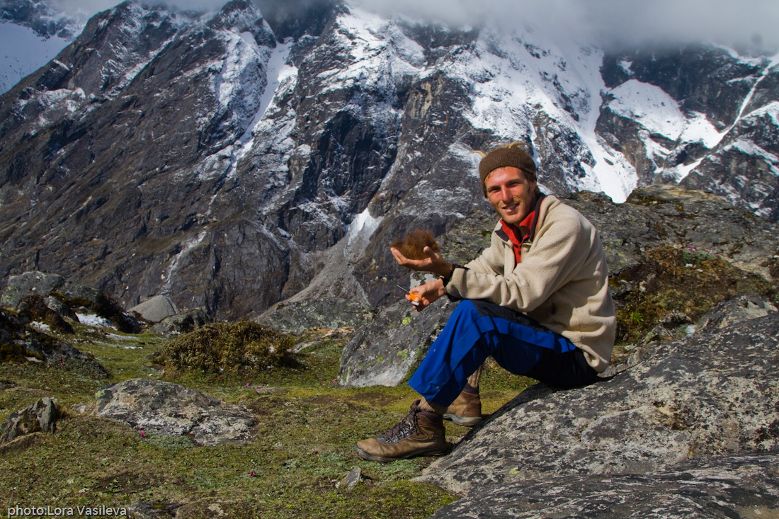
| Want some leeches? |
Finally we had to repeat backwards the six-day trek to Shivalaya through forests and rivers, passes and valleys, rain and mud, leeches and more leeches ... it looked endless. In Shivalaya it turned out that road is damaged because of the rains we had to walk a few more hours ... but what are a few hours compared to 25 days ... we also survived the 12-hour bus trip to Kathmandu and now we are resting from this adventure.
 |
| panorama from Kala Patar |


 We reached Shivalaya safely and here the road ended. Hereafter everything was brought by porters - from construction materials for houses such as doors, windows and roofs to meat, biscuits and cooking gas. A porter carried up to 150 kg on his forehead for days. And they didn’t look brawny and big people. We were loaded with food because we knew that the more we went, the more expensive it became. Otherwise we ate in the lodges Dahl Bat – rice, lentils, potatoes and spinach - the best Nepali meal, because when you finish it they give you second and sometimes third time. There were many lodges almost every hour and a double room cost like 0,50 euro per night. So we decided to leave the tent, it was not suitable for the monsoon season and we took more food instead. Now was the beginning of rains so there were almost no tourists, especially in the trip to Lukla. We had to go six days up and down to there. The trail was going up to the highest 3500m and descending to 1500m, passing over high passes and low valleys, rivers and villages with different ethnics. People were very hardworking and villages looked like Alpine - clean and solid stone houses and tidy gardens. It was amazing how they made terraces on the steepest slopes to plant rice, potatoes and vegetables. The houses are huge and massive, entirely made of stone. It was a hard work to carve them by hand and carry on the back. The diligence, patience and endurance of local people was incredible. They made their own food, brought running water from the streams to the house and made electricity from the sun or the river. In one word, they were almost independent of oil, vehicles and the civilized world. It was a strange feeling to go for a month without seeing a single car, and so many villages. People here are Buddhists and respect nature and animals. They don’t kill animals, not even leeches, flies or mice. They eat meat only if someone else killed it. And indeed, animals did not fear from people, you can push a fly with your finger and it won’t fly away.; the birds sometimes perched on us. We saw a few wild deer, but they quickly fled. Otherwise, the area has snow leopard (almost extinct), red panda and maybe Yeti, for which we heard legends.